Sunday, February 27, 2011
Wednesday, February 23, 2011
Greetings From Lake Bonifant

Here are some snapshots from my recent visit to scenic Lake Bonifant.


View Montgomery Sideways in a larger map
http://montgomerysideways.blogspot.com/2009/11/under-my-umbrella.html
Sunday, February 13, 2011
Two Weeks and 3 days ( 17 Days) Later
Tuesday, February 8, 2011
Twelve Days Later

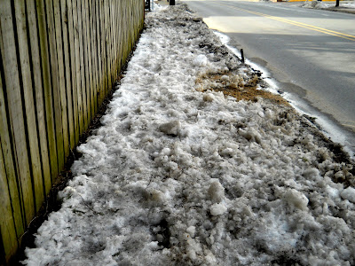
I took these photos on the way to downtown Silver Spring today, and the video on the way back. They show a substantial pile of plowed snow blocking the south side of Sligo Avenue between Woodbury and the ride-on bus stop near Fenton. Pedestrians are forced to walk in the street on this busy road. At night this is evn more dangerouse, as there is no street light at this location. TWELVE DAYS later.


Saturday, February 5, 2011
Va. man develops pothole app
Read this story at The Washington Post
I have been asking MCDOT to look into something like this to report pedestrian problems for a while now. It would only take a few reliable pedestrians with smart phones to asses a great deal of the pedestrian transportation system in a given area. A pedestrian safety app could utilize both the camera and GPS of a smart phone in conjunction with a brief description to notify MCDOT and SHA when there is a problem.

In June of 2008 I organized a pilot project test of PDAs used to gather pedestrian and cyclist conditions in downtown Silver Spring and East Silver Spring. While the data was not comprehensive, the 8 teams of two volunteers gathered more than 200 data points in under three hours. There data was a snapshot, but a continuously-updated, smart phone-based system could keep a running tab on things - including conditions at night, during inclement weather, and during construction.
Something akin to what I have set-up on Google maps could be used to collect data. The ability to overlay data from different sources could help MCDOT and SHA pick-up on formerly unseen patterns.
I have no idea what something like this would cost to maintain. The technology is off-the-shelf. Social media could play a major role. No training for the public needed. Include this in subsequent Street Smart campaigns. The possibilities are numerous...
Grab hold of the technology, Montgomery County. Find out what is going on with pedestrians - before they are hit.
I have been asking MCDOT to look into something like this to report pedestrian problems for a while now. It would only take a few reliable pedestrians with smart phones to asses a great deal of the pedestrian transportation system in a given area. A pedestrian safety app could utilize both the camera and GPS of a smart phone in conjunction with a brief description to notify MCDOT and SHA when there is a problem.

In June of 2008 I organized a pilot project test of PDAs used to gather pedestrian and cyclist conditions in downtown Silver Spring and East Silver Spring. While the data was not comprehensive, the 8 teams of two volunteers gathered more than 200 data points in under three hours. There data was a snapshot, but a continuously-updated, smart phone-based system could keep a running tab on things - including conditions at night, during inclement weather, and during construction.
Something akin to what I have set-up on Google maps could be used to collect data. The ability to overlay data from different sources could help MCDOT and SHA pick-up on formerly unseen patterns.
I have no idea what something like this would cost to maintain. The technology is off-the-shelf. Social media could play a major role. No training for the public needed. Include this in subsequent Street Smart campaigns. The possibilities are numerous...
Grab hold of the technology, Montgomery County. Find out what is going on with pedestrians - before they are hit.
Friday, February 4, 2011
Eight Days Later

This afternoon I set-off for downtown Silver Spring with my son, and I tool these photos along the way.


The sink hole in front of our home is larger and continues to grow.

Another sink hole has returned and is also growing larger.

The sidewalk in front of the unoccupied home nearby is still covered with ice,

Yet another sink hole forming further down the street.


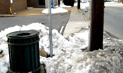
These photos show the section of sidewalk between Woodbury and the bus stop near Fenton. Still blocked with un-shoveled ice and snow. We walked on it - it is treacherous.There is still a large wall of ice blocking the sidewalk, and another blocking the bus stop.
One week and one day later, and Sligo Avenue is still effectively closed for pedestrians on the south side.http://montgomerysideways.blogspot.com/2009/12/montgomery-county-to-pedestrians-youre.html
Tuesday, February 1, 2011
The Great Wall

Last Saturday, January 29 I walked over to the intersection of East-West Highway and Blair Mill Rd. to participate in a site visit organized by Stephen Miller of Greater Greater Washington blog. The purpose was to inspect the section of sidewalk closed to the public at 1200 E-W Highway. The goup - which include people from the Dept. of Planning and SHA, the neighbor associatin president, a residnt with a wheelchair, someone ttaking video, and Regional Center Director Reemberto Rodriquez.
I brought a shovel along because I expected to come across a few blocked sidewalks along the way, and I wanted to be able to make my way without walking in the street. The going was a little rough. It would have been impossible for anyone who is not in good physical shape to make this journey. I didn't do a lot of digging on the way there - preferring to use the shovel to steady myself when climbing over the walls of now-solid ice that seemed to line every crosswalk and curb cut. A great wall of ice snaked through the streets of Silver Spring, cutting-off every curb cut and crosswalk for days.
 (photo taken before the storm)
I used the CSX bridge to get over Georgia Avenue. It was clear on top, but all of the stairs were covered in ice that made them unbeleiveably treacherous - but I managed. I walked under the bride to what was once the outlet of Blair Mill Rd and took a right at the SSCI building (the sidewalks on Georgia Avenue adjacent to this building had not been shoveled).

As usual, cars are parked on both sides of the crosswalk here. As usual, cars are speeding through the crosswalk as they cut-through to E-W Highway or enter the parking deck for The Veridian. No one with a wheelchair could get through here, and anyone crossing between the cars had to be extra-careful to be seen.
When I got to the crosswalk at E-W Highway just south of the intersection,I took out my white cane and prepared to cross at the crosswalk - which was completely block by a two-footwall of ice that had been plowed off of the road surface. As I waited for the light to turn white, I watched in horror as a couple with a stroller ran across the street against the light.

When they reached the near side they realized that they had no way across. The man noticced that I had a shovel and asked if he could borrow it. I said yes, under the condition that he promise never to cross against the light again. I threww my cane down and handed him the shovel. After a few seconds I asked for the shovel back, and dug frantically to open the curb cut for them. After another few moments I had cleared a narrow path for them, and I help the woman pull the stoller over. I told them again that what they did was not really very smart, and that a few extra moments aren't worth your life. The man tried to tell me that they had no other choice. OK - whatever you say...
I picked up my cane and pressed the signal button to cross again. On the far side I dug out the curb ramp. While I was doing this, the meeting group beagan to form on the far side. I took a photo while I was waiting for the light to change. I began the meeting sweaty and blown, but at least this one location was open. This allowed the wheelchair-bound member of our group to get where the meeting was taking place.

The meeting began with a discussion of the conditions at this intersection, which were disappointing, to say the least. According to the rep from SHA, there were several problems here - the first being that access to the NE corner and the adjacent crosswalk had not been cloed-off, as we had been told it would be almost a month ago. As we watched, several pedestrians crossed here. The signal light was still uncovered - actually encouraging pedestrians to use this unsafe infrastructure. None of the approaching sidewalks had closed signs. This construction sight was a major obstruction, and yet there were almost no safety measures in place. In effect, the crosswalk that was supposed to be closed was still open and advertising that fact, and the crosswalk that was supposed to be doing all the work was blocked by ice. A no-win situation, for sure. The man from SHA seemed perplexed by the lack of measures he had assured us would be taken, assured us once again that they would be in place on Monday. (I have not been back to check).
Our discussion made it clear that here are two problems here - the problems at this specific location, and the systemic problems that allowed these conditions to exist and persist - despite numerous complaints over three years. Of course, this is not a new topic of discussion in Montgomery County.
The closure of sidewalks adjacent to constructions site here has been a regular occurence for as long as anyone can remember. Even though Planners have clearly stated that sidewalk closures should be allowed only as a last resort, closures are the rule, not the exception. Most construction site in Montgomery County feature closed sidewalks at some point during the project. Many do so for years.
The guys from GGW blog took video and interviewed me and others there. I am interested to see how this all works out.
Subscribe to:
Comments (Atom)


